// BLOG // Coverage for France now available
We are pleased to announce an exciting addition to our offering: New, high-quality geodata is now available for France! This includes RGE ALTI 1m, BD TOPO LoD1 buildings and cadastral data.
What is the new data?
RGE ALTTI 1m
RGE ALTTI 1m is a high-resolution terrain model that provides accurate elevation values throughout the French territory. With a resolution of 1 meter, it enables precise analyses and applications in a wide range of areas.
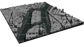
BD TOPO LoD1 Buildings
BD TOPO LoD1 Buildings provide a simplified 3D representation of buildings with correct elevation. These models reproduce the basic geometric shapes of buildings, which is particularly useful for urban planning and visualization.
Cadastral data based on PCI
Our new cadastral data includes detailed information on property boundaries and sizes in France.BD ORTHO 20cm
Detailed aerial images with up to 20cm resolution.
How to access the new data?
Simply select the desired area in France on our interactive map and you can download all the data available for this location bundled in one package, e.g. as a DXF or OBJ file. Ready for import into your CAD software.