// BLOG // Allplan 2024 launched with 3DCityLoader Integration
In the age of digitalization and Building Information Modeling (BIM), efficient and precise tools for architectural and urban planning are indispensable. Allplan, a leading software solution in the field of BIM and CAD, has taken a major step forward here with the release of Allpan 2024. With the new Allplan GIS Connector, which draws on our extensive range of geodata, Allplan, together with 3DCityLoader, offers an innovative solution for the seamless integration of GIS data into planning processes. By integrating this data into planning, architects can gain a better understanding of the spatial environment and make informed decisions.
What is the Allplan GIS-Connector?
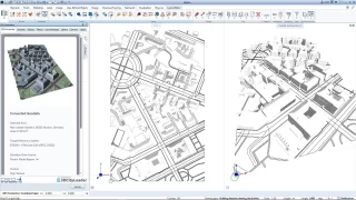
The Allplan GIS-Connector is a powerful extension in Allplan 2024 that allows you to import geographic data from 3DCityLoader directly into your Allplan project. The familiar and user-friendly selection tool is displayed directly in Allplan and allows you to configure the data package individually. Once the file has been created, a preview is displayed and the data can be imported directly into the project with just one more click.
This eliminates the time-consuming process of collecting, downloading and importing data from various sources, which may have to be converted beforehand.
What data is available?
The GIS-Connector draws on our complete range of data. Depending on the region, the following data categories are available:
Terrain models with a resolution of up to 0.5m
3D building models from local sources in LoD 1 - 3, or worldwide on the basis of Open Street Map
Parcels and buildings from the real estate cadastre
Textures or aerial images (DOP) or OSM maps
Road courses based on Open Street Map
The terrain models can be imported either as a polyhedron with texture, individual terrain points or as a proxy object (point cloud, DTM).
Give it a try!
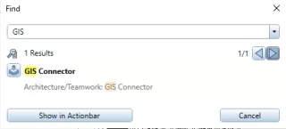
As of Allplan 2024, the easiest way to find the GIS connector is to search for "GIS" (magnifying glass icon in the top right of the action bar). Of course, you can also add the GIS Connector permanently to your Actionbar.
If you are not yet using Allplan 2024, there is also a free trial version.